Panama Canal Zone Photography and U.S. Occupation in Panama, 1915
Photograph
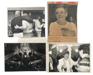
Unknown photographer, Panama Canal Zone and local life photo archive, 1915, documents Panama during the first year after the canal’s opening to traffic and supports research into U.S. imperial administration, Canal Zone settlement, travel photography, military protection of infrastructure, and the visual ordering of colonial space. The Panama Canal opened to traffic on August 15, 1914, after U.S. construction created a strategic interoceanic route administered through the Canal Zone, and Balboa Heights became a key administrative and residential center for the U.S.-controlled canal system. These photographs capture the built and natural environment through which American authority was made visible: locks, river landscapes, official buildings, hilltop housing, city views, and naval practice appear together as evidence of a recently completed engineering project becoming an occupied administrative territory.Twenty-four original silver gelatin photographs, including two real photo postcards, dated 1915 with some undated images, several with handwritten inscriptions in English on versos and some with printed captions on rectos. Photographs measure approximately 3½ x 5 inches to 5½ x 7 inches. The archive includes views of the Chagres River, the largest river in the Panama Canal drainage basin and a major part of the canal water system, together with photographs of the Gatun Locks, canal gates, aerial views of Panama City, the main city plaza, a bull ring, and Balboa Heights. The Balboa Heights images show American-style bungalows arranged along curving terraced roads, with broad verandas, raised foundations, and landscaped grounds, visual evidence of the residential hierarchy attached to U.S. canal administration. Additional images show the Administration Building at Balboa Heights, completed in 1914 and positioned above the town as a central administrative landmark, while a real photo postcard captioned “Ready to Fire—Division Practice” shows U.S. naval boats in formation off the coast, connecting sightseeing views to the military protection of the newly opened canal.
The archive’s research value lies in its combination of personal travel documentation, official-looking captioned views, urban and infrastructural scenes, and military imagery from the early Canal Zone era. Its views of Balboa Heights are especially significant because U.S. canal society was organized through racialized and occupational distinctions, including the “gold roll” and “silver roll” labor categories that separated white American workers from largely Black Caribbean and Latin American workers and shaped housing, pay, and privilege within the zone. Light edge wear, legible inscriptions, and preserved image surfaces, very good overall. Cohesive Panama Canal Zone photo archive documenting the immediate post-opening landscape of U.S. power in Panama through canal infrastructure, river systems, segregated administrative space, urban views, and naval readiness.
Item #22448
Price: $450.00
See all items in Imperialism & Colonialism, Mexico, South & Central America
See all items in International & Global Culture, Photography, Archive
See all items by Panama City and Canal
See all items in Panama
Suggested Imperialism & ColonialismBrowse All


Suggested Mexico, South & Central AmericaBrowse All


Suggested International & Global CultureBrowse All


![LGBTQ] Le secret du Chevalier d'Éon 1959 Original French Movie Lobby Card Poster and. Chevalier D'Eon Film.](https://maxrambod.cdn.bibliopolis.com/pictures/18670.jpg?width=320&height=427&fit=bounds&auto=webp&v=1683064545)
Suggested PhotographyBrowse All