

Connecticut River Flood and Failed Infrastructure Photo Archive, Springfield, Massachusetts, 1936
Photograph
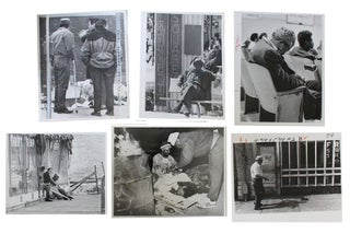
Springfield Massachusetts flood photographs documenting the March 1936 Connecticut River disaster in western Massachusetts, with direct evidence of how floodwater moved through streets, bridges, utility plants, churches, and commercial blocks in one of the worst flood events in regional history. Images record the city at the point where river flooding became an urban systems failure, not only inundating homes and business districts but also interrupting power, transport, and street circulation in a manufacturing center already under Depression era strain. The 1936 flood in Springfield formed part of the larger New England catastrophe that left 15,000 city residents homeless and pushed federal and local authorities toward new flood control measures, including the broader post 1936 buildout of levees, dikes, and river management works under the Flood Control Act of 1936.Photo archive of 16 sepia photographs with printed captions on lower margin, 3.25" x 4.75", Springfield, Massachusetts, 1936. The photographs are captioned beneath the image area with specific locations, including “North Main St. Flood Scene,” “Plainfield Street,” “Flood Barricade, Telephone Bldg.,” “St. James M.E. Church,” “U. E. Light Power Plant,” and “Railroad Bridge, Conn. to name a few. Several views show entire streets turned into waterways, with tree trunks, porches, and first floors standing in still floodwater. One Plainfield Street view shows two men navigating a rowboat between commercial buildings. The Telephone Building appears protected by sandbags stacked across low window openings showcasing emergency defense. The St. James M.E. Church photograph shows water standing nearly to the base of the windows around the church grounds. Memorial Bridge and the railroad bridge are both shown against a swollen Connecticut River, while the riverfront and power plant views place industrial and utility structures at the flood edge. The Locust and Main Street image shows crowds, boats, automobiles, and rescue activity gathered at a flooded intersection, and the State Street at Main view shows a truck moving through deep water in the downtown business district. The South Main Street and South End views extend that disruption into retail and industrial blocks, where storefronts, sidewalks, and roadbeds disappear under the flood.
The flood followed a severe winter, deep snowpack, frozen ground, and heavy March rain across the Connecticut River Valley. In Springfield and nearby West Springfield, existing dikes were overtopped, undermined, and eroded, while floodwater cut off neighborhoods and disabled normal traffic. The Connecticut River Valley was a manufacturing corridor the surrounding area was still recovering from the Great Depression; this economic downturn resulted in greater structural change. The disaster helped drive the Flood Control Act of 1936, and in West Springfield the U.S. Army Corps of Engineers began a local protection project in 1939 to enlarge and rehabilitate flood defenses completed in 1942. Light wear and mild toning; captions remain clear and the photographs present well. Overall very good condition. A visual documentation of the flood that forced Springfield to reshape the infrastructure of their river front environment.
Item #23304
Price: $450.00
See all items in Natural & Industrial Disasters, Massachusetts, Natural & Industrial Disasters
See all items in American History & Americana, American History by State, Labor, Environment & Industry, Archive
See all items by Connecticut River Flood
See all items in Massachusetts
Suggested Natural & Industrial DisastersBrowse All


Suggested MassachusettsBrowse All


Suggested Labor, Environment & IndustryBrowse All


Suggested American History & AmericanaBrowse All