


Oregon's Vanport Flood and Infrastructure Disaster Photo Archive, Portland, 1948
Photograph
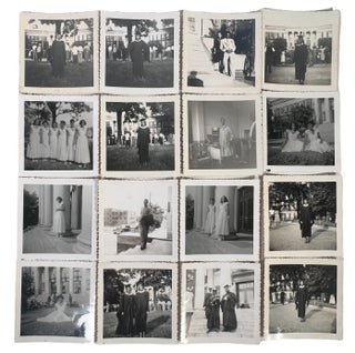
Portland flood photographs recording inundated streets, industrial buildings, freight trackage, and emergency response in the Vanport Flood of 1948, marking the reshaping of Oregon's then second largest city. The group centers Portland rather than Vanport itself, showing the working city under water at a moment when warehouses, bridges, rail sidings, and low lying industrial streets remained exposed to the wider regional emergency. Several manuscript captions tie the photographs to SE 3rd and Madison and to the Morrison Street Bridge, placing the archive within the transport and warehouse network that linked downtown Portland, river crossings, and freight distribution during one of the most consequential flood events in Oregon history.Photo archive of 8 black and white photographs, ranging from 2.5" x 3" to 3" x 4.5", Portland, Oregon, June 1948. Verso captions include "Portland Oregon Flood June 1948 SE 3rd + Morrison," "Morrison Street Bridge. Flood of June 1948," "Shovelling sand bags," and "Pumping water from the basement." The photographs show floodwater covering streets to curb height, a truck discharging water into the roadway, workers and pedestrians standing beside sandbag piles outside a brick warehouse building, and a woman moving through pooled water between freight cars and stacked sacks. One view shows parked automobiles half surrounded by floodwater in front of a warehouse entrance bearing the sign "Fairbanks Morse & Co.," while another frames a broad flooded roadway lined with utility poles, commercial buildings, and roadside signage receding into the distance. A horizontal river view of the Morrison Street Bridge situates the inundation within Portland's river crossing system, and the recurring presence of rail cars, warehouse fronts, and industrial lots makes clear that the archive centers the city's commercial and transport landscape rather than domestic flood damage alone.
The June 1948 flood transformed Portland's relationship to its rivers and floodplain, exposing the vulnerability of the city's industrial margins just as the Vanport disaster displaced roughly 18,000 residents and reshaped postwar Oregon. Minor edgewear and light curling. Overall very good condition. A ground level record of one of Oregon's biggest natural disasters.
Item #23249
Price: $485.00
See all items in Natural & Industrial Disasters, Oregon, Environment & Resources
See all items in American History & Americana, American History by State, Labor, Environment & Industry, Archive
See all items by Oregon's Vanport Flood Portland
See all items in Oregon
Suggested Natural & Industrial DisastersBrowse All


Suggested Environment & ResourcesBrowse All


Suggested OregonBrowse All


Suggested American History & AmericanaBrowse All