Sixteenth Century European Mapping of the Near East: Münster Woodcut Map of Arabia Felix, Arabia Deserta, and Syria
Posters, Broadsides, Prints, Maps, &
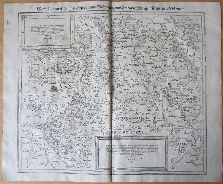
Münster, Sebastian. Map of Arabia, Syria, and Mesopotamia published in Cosmographia, 1598, produced by the German humanist scholar whose geographic writings helped revive and popularize world geography in Renaissance Europe. Sebastian Münster, a Hebrew scholar and cosmographer active in Basel, issued Cosmographia in 1544 as the first major German language description of the known world. The book combined historical geography, travel knowledge, and cartographic illustration, becoming one of the most widely read geographic works of the sixteenth century. Maps issued within Cosmographia introduced European readers to the political and geographic layout of regions across the Mediterranean, Middle East, and Asia at a time when expanding trade networks and diplomatic contact were reshaping European knowledge of global geography.Münster, Sebastian. Map of Arabia, Syria, and Mesopotamia. Basel: published in Cosmographia, 1598. Woodcut map depicting the eastern Mediterranean and Arabian Peninsula as understood by European cartographers during the late sixteenth century. The map prominently labels the traditional geographic divisions of the peninsula including Arabia, Arabia Deserta, and Arabia Felix, while also illustrating Syria and Mesopotamia to the north. The engraving presents a dense geographic layout including rivers, lakes, mountain ranges, and more than one hundred fifty identified cities and settlements across the region. The map reflects the mixture of classical geographic traditions and early modern European knowledge characteristic of sixteenth century cartography; notable omissions include the island of Bahrain and the peninsula of Qatar, features not yet consistently represented in European maps of the period.
Münster’s Cosmographia became one of the most influential and widely circulated geographic works of the sixteenth century, appearing in numerous editions and languages across Europe. Its maps and illustrations introduced broad audiences to visual representations of world geography during a period when printed cartography was rapidly expanding alongside European commercial and diplomatic engagement with the Middle East and Asia. The work played a central role in shaping geographic knowledge for readers who encountered distant regions primarily through printed books rather than direct travel accounts. The map’s elaborate calligraphic labeling and densely populated landscape reflect the Renaissance effort to integrate classical geographic traditions with newly circulating information about the eastern Mediterranean and Arabian world. Sheet measuring approximately 16 x 13 inches with original centerfold from binding. General age toning with two small wormholes within the printed area, not affecting legibility or visual impact. Overall very good condition.
Item #14464
Price: $750.00
See all items in Arabia, Middle East
See all items in International & Global Culture
See all items by Sebastian Munster
See all items in Arabia
Suggested ArabiaBrowse All


Suggested Middle EastBrowse All


Suggested International & Global CultureBrowse All