


Glen Canyon Dam and Colorado River Basin, Documenting Competing Federal and Industrial Visions of the Colorado River and its Irreversible Transformation, 1949-1970s
Archive
[Environmental Policy] [Glen Canyon] Archive of federal and regional Colorado River Basin materials documenting how the river was successively treated as scenic terrain, engineered water infrastructure, and regulated recreation landscape across the mid twentieth century. The group centers on Glen Canyon and the broader basin as federal agencies, development planners, and conservation advocates advanced competing uses for the river. Engineering maps, government surveys, construction photographs, ecological advocacy newsletters, and environmental planning documents establish the process by which canyon landscapes were converted into measurable storage systems, dam sites, recreation zones, and administratively managed federal space.Colorado River Basin, with material tied to Arizona, Utah, and the broader American West. 1946-1979, Archive of 26 items, including 3 engineering maps, 4 press silver gelatin photographs, 15 issues of Peak and Prairie (Sierra Club Rocky Mountain Chapter newsletter), 1 Colorado River Storage Project pamphlet, 2 government publications, and 1 National Park Service NEPA circulation letter. Visible material includes contour maps and storage-capacity graphs reducing canyon topography to projected reservoir form; black-and-white press photographs showing Glen Canyon Dam under construction, diversion tunnels, excavation, and early recreation on Lake Powell; and printed federal planning documents focused on road systems, zoning, wilderness recommendations, and recreational use after inundation.
[1] A Survey of the Recreational Resources of the Colorado River Basin. United States Department of the Interior, National Park Service, 1950; compiled from 1946 fieldwork. Government publication establishing a pre-dam baseline for the basin’s scenic and recreational assessment. The volume includes 13 folded maps in the rear pocket charting river corridors, proposed reservoirs, and basin-wide topography, preserving a record of landscapes later submerged or reclassified under postwar development plans.
[2] Engineering maps for Boulder Canyon and Dewey Dam sites. Circa mid twentieth century. Three technical maps converting river terrain into contour lines, section views, and storage curves for projected impoundment and control. Their emphasis on capacity, grade, and reservoir profile shows the bureaucratic and engineering language through which the basin entered federal planning systems.
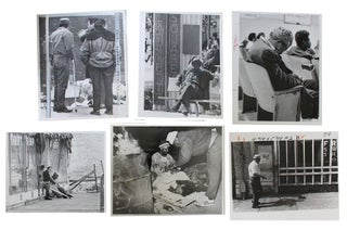
[3] Press silver gelatin photographs of Glen Canyon Dam construction and early Lake Powell use. Circa 1960-1966. Four press photographs showing dam works within the canyon, including diversion tunnels, excavation, concrete placement, and recreational boating on the new reservoir. Verso captions from the Bureau of Reclamation and Associated Press cite “more than one million cubic yards of concrete” and the “pouring of first concrete for the dam proper,” linking the images to federal publicity and construction chronology.
[4] Colorado River Storage Project. Bureau of Reclamation pamphlet. Mid twentieth century. Public-facing promotional publication presenting the storage project as a large-scale federal development program for water control and regional growth. Its language praises Glen Canyon Dam as “one of the great dams of the world,” making clear the official rhetoric used to justify transformation of the river through reclamation policy.
[5] Peak and Prairie. Sierra Club Rocky Mountain Chapter newsletter. Fifteen issues, early 1970s. Regional environmental newsletters reporting on conservation campaigns and debates over western energy, water, and land use. Within this group, the newsletters supply contemporaneous advocacy evidence that federal river development was being contested in organized print networks rather than treated as a settled engineering program.
[6] Glen Canyon National Recreation Area: Proposed General Management Plan / Road Study Alternatives / Final Environmental Statement. National Park Service, July 1979. Federal planning document setting out zoning, road alternatives, and wilderness recommendations for the recreation area created after completion of the dam. In contrast to the earlier survey and engineering material, this document shows Glen Canyon as a managed recreational and environmental jurisdiction governed through formal planning categories.
[7] National Park Service circulation letter citing Section 102(2)(c) of the National Environmental Policy Act. 1979. Official letter announcing distribution of the final environmental statement and inviting public comment. The document provides direct evidence of the procedural side of late twentieth century environmental governance, in which major federal land-use decisions required circulation, review, and recorded administrative response.
Across the group, the 1950 survey preserves the basin before inundation, the engineering maps and construction photographs record its conversion into infrastructure, and the 1970s Sierra Club and National Park Service material shows subsequent conflict and regulation after Glen Canyon Dam’s completion in 1964. The archive therefore documents a shift in federal treatment of the Colorado River Basin from scenic and recreational appraisal to industrial water control and then to environmental review under NEPA-era law.
Handling wear across materials; photographs retain strong contrast with legible captions; maps with expected fold lines; bindings intact. Overall very good condition. A concentrated documentary group on the administrative, visual, and environmental remaking of the Colorado River Basin in the postwar American West.
Item #23102
Price: $1,450.00
See all items in Urban Development & Industrialization, Arizona, Colorado, Utah, Environment & Resources
See all items in American History & Americana, American History by State, Labor, Environment & Industry
See all items by Colorado River Glen Canyon Dam
See all items in Arizona; Utah
Suggested Urban Development & IndustrializationBrowse All


Suggested Environment & ResourcesBrowse All


Suggested ArizonaBrowse All


Suggested UtahBrowse All