Cartographic Americana: Nicolas Sanson’s America Settentrional with California as an Island, Italian Edition circa 1690
Posters, Broadsides, Prints, Maps, &
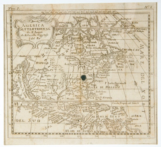
Sanson, Nicolas. America Settentrional, circa 1690, is an Italian edition of Sanson’s influential seventeenth-century mapping of North America and preserves one of the most enduring cartographic misconceptions of the early modern Atlantic world: California shown as an island. The map supports research into European geographic knowledge, the circulation of French cartographic models through Italian publishing, and the persistence of speculative geography in printed maps of the Americas.America Settentrional. Nicolas Sanson. Italy: n.p., circa 1690. Measures 6 inches by 7 inches, matted and unframed. The map includes a small decorative title cartouche and “Tom. I” printed in the upper left corner. California is depicted as an island, with the less common indented northern coastline and “R. de Eslite” at the tip, rather than the more frequently encountered flatter northern California coastline sloping eastward. The map derives from Sanson’s 1650/1656 prototype of North America; McLaughlin and Mayo’s California as an Island identifies French, Dutch, and Latin editions, but no Italian edition is noted in the supplied description.
Light water stain in the upper left corner, ink stain in the center of the image and far right margin, scattered soiling, and fold separations reinforced; very good. A compact but historically resonant Italian Sanson map, notable for its Island of California geography and for a coastline variant associated with scarcer states of this influential cartographic tradition.
Item #12792
Price: $425.00
See all items in Other (American History), California
See all items in American History & Americana, American History by State
See all items by 1650 North America Map
See all items in California
Suggested Other (American History)Browse All


Suggested CaliforniaBrowse All


Suggested American History & AmericanaBrowse All


Suggested American History by StateBrowse All