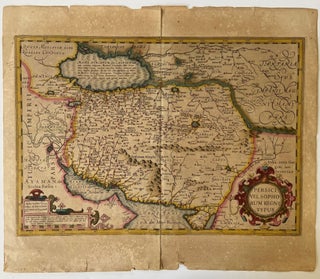
Early Modern Cartography of Safavid Iran in Hand Colored Map Persici Vel Sopho Rum Regni Typus, 1606
Persici Vel Sopho Rum Regni Typus, 1606, presents an early seventeenth century European cartographic rendering of Safavid Iran, documenting how Persia was geographically understood and visually represented during the height of Safavid political authority. The map identifies the region within a broader network of imperial borders extending toward Russia and.....