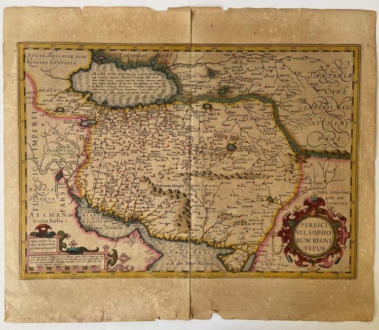
1606 Hand Colored Map of Iran- Persia and
Map
Very early 1606 hand colored map of Iran during the Safavid dynasty. 1606. Measures 21.5 x 18 inches. Map shows Iran and its borders as they existed in 1606 with the Caspian Sea drawn horizontally, not yet conceived of as vertical in shape. Text is in Latin. Map shows what is now known as the Persian Gulf labeled "Sinus Arabicus". This map is hand painted in shades of pink, gold, and turquoise, its colors still rich and images crisp, we can not date the coloring. Includes Iran's borders with Russia and India during the 1600's, even shows Kabul as an Iranian city. The Safavid dynasty thoroughly intermarried with both Pontic Greek and Georgian lines establishing powerful allies throughout the region. Detailed drawings outline the dimensions of mountains and bodies of water with the many villages throughout the region marked with small pink dots. Ornamental cartouches at the bottom of the page, outlining text on both sides. One side framed in an ornate circle of pink and green reads, "Persici Vel Sopho Rum Regni Typus." Fold mark at center. A few very small tears along the bottom edge do not affect image or text. Text written in French on verso includes the subtitle "le royavme des perses of l'empire des sophy," translated to mean the history of the kingdom of the Persians of the empire of the Sophy. The Age of Discovery was a period marked by European exploration recorded and distributed with maps like this one. One small half-inch black ink mark on left side, not affect image or text. In very good condition.Item #18226
Price: $750.00
See all items in
Maps and Travel,
Middle East and Asia
See all items by Geography Iran
SUGGESTED ITEMS